
YachtPassage – when to cast off, which way to go
YachtPassage plans your passage around the weather. Choose start and destination, set up your boat – the app shows when best to cast off and which way to go. For sail and motor, on iPhone on the go, on iPad and Mac at the chart table or desk. Developed by Navismare from more than 30 years of yacht deliveries.
What YachtPassage does
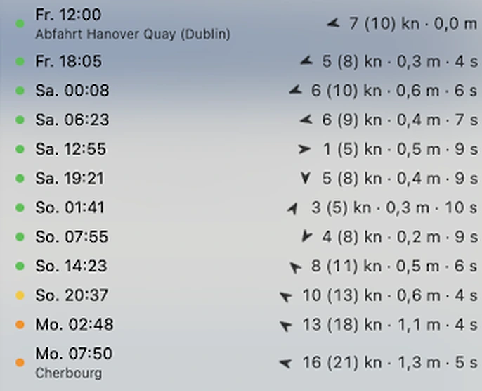
The forecast changes, the question stays: cast off now or better later? YachtPassage works out the best route for every departure over the next five days on your device – from wind, gusts, sea state, tide, range, fuel stops, canals and daylight – and shows the result as a traffic light. The sailing yacht gets the best wind route, the motor yacht the shortest feasible way in little sea.
🚦 Departure windows as a traffic light
15 departures over the next five days, each with passage time, wind, gusts and waves along the route. Green, amber or red – measured against your own limits for gusts and wave height. The best window comes first, with the reasons.
⛵ Sailing yacht: a route by the wind
The app looks for the way with the best wind and uses the engine where it is not enough. Headwind sections are marked, with a suggestion for a break in harbour.
🛥️ Motor yacht: short way, little sea
The shortest feasible way in the calmest possible sea – with consumption, range and reserve from your own boat data.
🌬️ Weather from current models
Wind, gusts, sea state and currents from current forecast models (including ECMWF and DWD ICON) up to four days ahead. Anything beyond is dashed and marked as an estimate – the app never invents weather.
⚓ Harbour to harbour
If the weather does not allow the passage in one go, the app plans legs from harbour to harbour. You set the time at sea per leg and “daylight only” yourself.
⛽ Harbours and fuel stations
More than 14,700 harbours and around 1,600 fuel stations in Europe. Plan fuel stops and stopovers straight into the route; the app recalculates it with the stop.
🌊 Tidal windows and canals
Tidal windows for the Strait of Gibraltar, the Strait of Messina, Dover, Alderney Race, Raz de Sein and Chenal du Four. The Kiel Canal with daytime transit hours and waiting berths, the Elbe with the stream.
🛡️ Traffic separation schemes
The route crosses traffic separation schemes at right angles only. Keep close to the coast if you like.
📤 GPX and passage plan as PDF
The route as GPX for your chart app, for example YachtNav, and the passage plan with legs, times and fuel stops as a PDF for crew and ship’s papers.
The departure windows at a glance
Free download, one-time unlock
- Free: downloading the app, the map, harbours and fuel stations
- Two passages free of charge: try route calculation on two passages.
- Then a one-time €33.99: one purchase unlocks route calculation for good – on all devices with the same Apple ID. No subscription, no account.
A planning aid, not a navigation app
YachtPassage is made for preparing a passage and shows no nautical charts. Weather is a forecast: recalculate before casting off and use official marine forecasts, charts and Notices to Mariners. At sea you navigate with charts or a chart app. The skipper remains responsible for boat and crew.
YachtPassage – coming November 2026
For iPhone, iPad and Macs with Apple silicon, in English and German. Questions about the app? Support is answered by the same people who build it.