
YachtNav – the chartplotter for skippers
Built by Navismare on more than 30 years of yacht delivery experience: course chart with steering guide, route navigation with automatic waypoint switching, wind and wave forecast, tide planner, AIS monitoring with distress beacon alarm, crew watch schedule, ship's logbook, fuel calculator and iCloud sync in one app – designed for the iPad at the helm. Deutsch, English, Español, Português, Français.
The sister product to YachtLog: YachtLog plans and documents the passage – YachtNav navigates it.
What YachtNav does
YachtNav is the chartplotter for under way: the chart with its marks, and over it a clean cockpit that shows exactly what matters at the helm – speed, steering correction, next waypoint, fuel. Behind it work route logic, weather and tide models, AIS monitoring, crew management and a ship's logbook that largely keeps itself – kept in sync across your devices via iCloud.
🧭 Cockpit with steering guide
SOG large and central, next to it the course guide: the degree figure is the steering correction – red to port, green to starboard. Plus bearing, distance, time to go and ETA to the next waypoint, and GPS accuracy.
🗺️ Chart, satellite, night mode
OpenStreetMap base map with OpenSeaMap seamarks, night mode with adjustable dimming – and offline chart storage: the download button in the route list stores the charts along the route on the device. The search finds harbours and any place, each with its distance from your boat.
📍 Routes & GPX
Tap routes directly into the chart or import them as GPX (OpenCPN, iSailor and more). On activation, the app joins at the nearest leg; waypoints switch automatically once passed abeam.
🗓️ Passage plan
The passage worked through before you cast off: ETA for every waypoint, twilight and darkness by true sun position (nautical twilight), tidal gates with high and low water at your expected arrival, and the fuel required against what is left in the tank. With a route active the plan keeps recalculating from actual speed and marks the selected waypoint. Exports as an A4 PDF.
🌬️ Wind & waves on the chart
Load the GFS wind forecast for the route area, step through it with the time slider – or import your own GRIB files. Plus the wave forecast with height, direction and period, computed right up to the coast. Both overlays are drawn directly on the chart.
📡 AIS with target list & distress alarm
YachtNav connects to the on-board WiFi gateway and shows AIS targets on the chart – plus the target list, sorted by threat (CPA/TCPA). Distress beacons such as SART, MOB and EPIRB trigger an immediate full alarm, harbour mode mutes routine alarms in busy waters, and your own transponder echo can be marked as own ship.
🌊 Tide planner
For any point on the chart: the 48-hour tide curve with the next high and low waters – and passage windows for tidal gates like Alderney, Gibraltar or the Elbe, read straight off the curve.
🔔 Navigation alarms
The app keeps watch with you: alarms for cross-track error beyond your limit, for arrival at the waypoint and for GPS loss – audible even with the display locked.
👥 Crew & watch schedule
Add your crew, choose watch length and manning – YachtNav builds the fixed watch schedule for the whole crew, and the skipper is spared the dog watch. Reassign with a tap, export as text for WhatsApp or email.
☁️ iCloud sync
Routes, marks, tracks, crew and the watch schedule move automatically between iPhone and iPad – no account, no third-party servers, straight through your private iCloud.
📐 Bearing & distance
Bearing and distance right on the chart: tap a point, read course and reciprocal – for position lines, abeam bearings and quick distance checks.
📖 Ship's logbook
The track starts with the route, manoeuvres are logged with one tap – every entry automatically stamped with position, speed, course and forecast wind. Plus hourly position entries, watch changes with names, and PDF/GPX export. The track library collects completed passages with total miles per yacht, and the recording survives an app restart.
⛽ Fuel calculator
Two consumption points – displacement and planing – are enough: the app converts automatically according to GPS speed and shows hourly consumption, remaining fuel and the fuel needed to the waypoint. Below 15 % it warns with an alarm sound. After filling up, it calibrates the figures against real consumption on request.
🆘 MOB & emergency
The MOB hold-button freezes the position and shows bearing, distance and time in the water plus the quick-stop procedure. The emergency card provides the radio call template with vessel data and position; received distress positions can be marked on the chart and steered to directly.
⚓ Anchor watch
Set the anchor, choose the swing radius – if the boat leaves the circle, the app raises an alarm.
The app in action
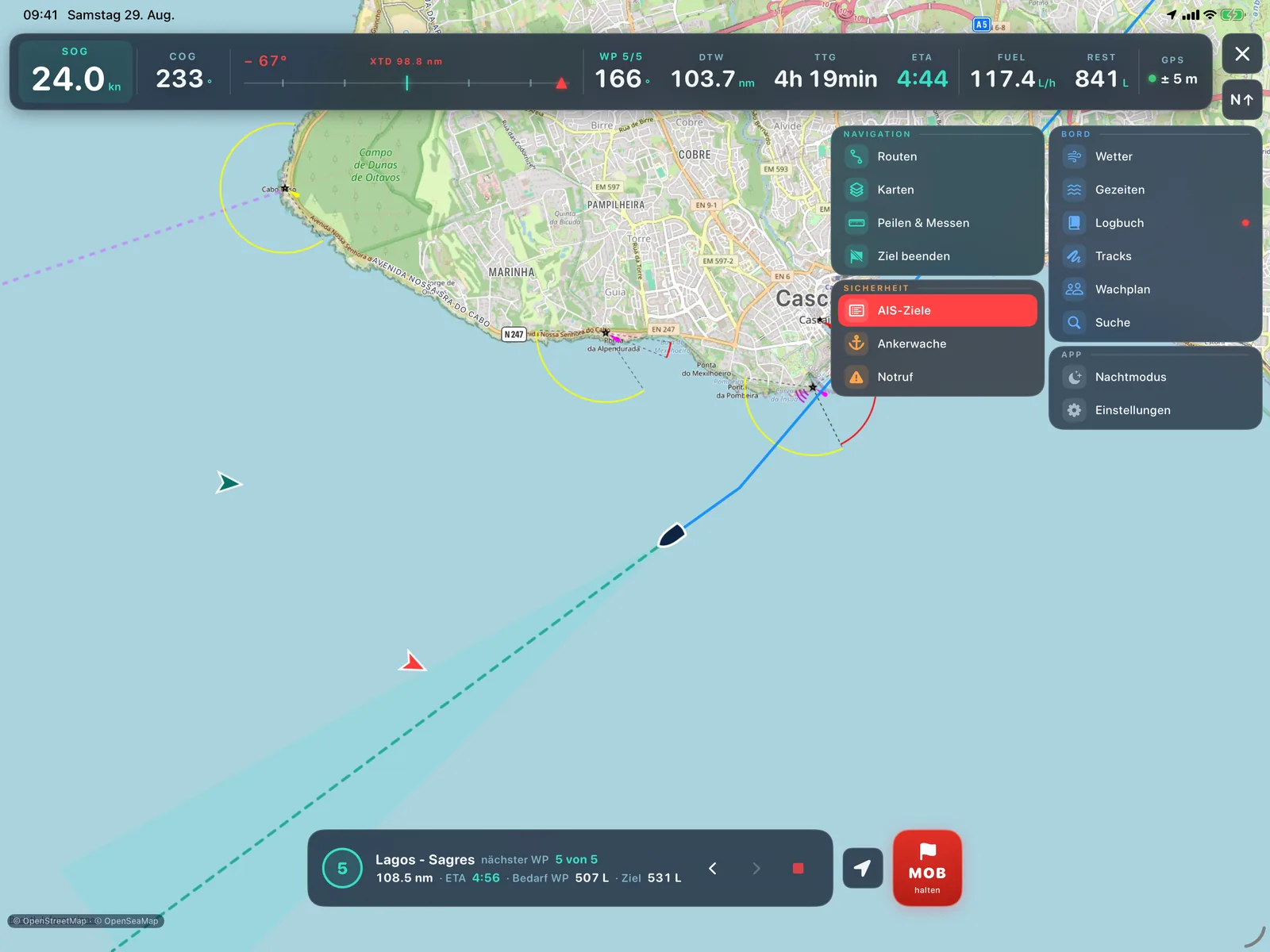
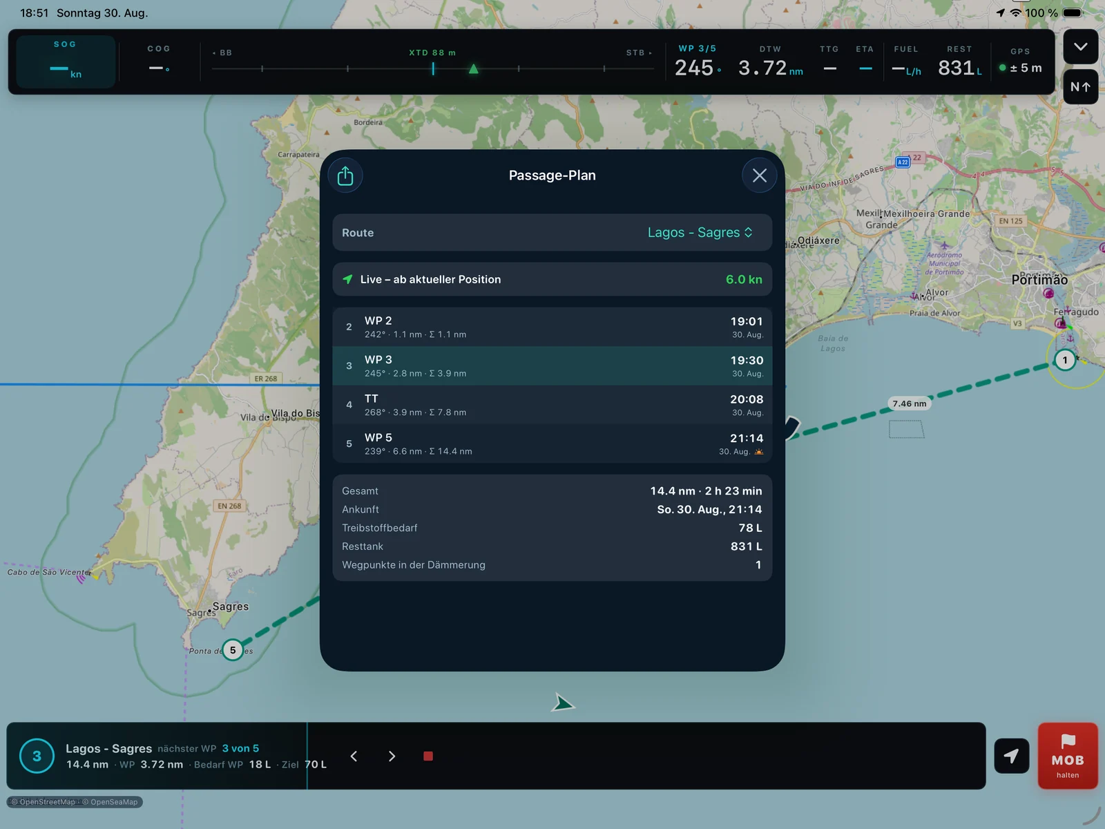
All features at a glance
Navigation
- Cockpit bar with SOG, COG, course guide (XTD) and steering correction in degrees
- Target data for the next waypoint: bearing, distance, time to go, ETA
- An ETA on another day is shown with the date; waypoint distance runs along in the route bar
- Create, rename and activate routes – joining at the nearest leg
- Automatic waypoint switching abeam, manual switching at any time
- GPX import from OpenCPN, iSailor and other apps
- Go-to function: press and hold the chart, set course
- Search for harbours and any place – with distance from your boat
- Bearing & distance tool: course, reciprocal and distance to any chart point
- Navigation alarms: cross-track error, arrival at the waypoint, GPS loss – also with the display locked
- Passage plan: ETA per waypoint, twilight and darkness by sun position, tidal-gate warnings, fuel required
- Live mode: the passage plan keeps recalculating from actual speed under way; PDF export
- Save dialog for new routes, with the option to activate immediately
- GPX export of your own routes and marks
- Go-to by long press on the chart, with an end button right beside it
- The course line follows the direction actually being made good
- A centre button appears as soon as the chart has been panned
- Set and name marks
Charts & weather
- OpenStreetMap base map with OpenSeaMap seamarks
- Offline chart storage along the route (download button per route)
- Night mode with adjustable dimming
- GFS wind forecast for the area of the active route
- Wind overlay with time slider directly on the chart
- GRIB import from your own sources
- Wave forecast with height, direction and period – right up to the coast
- 48-hour tide curve with high and low waters for any chart point
- Satellite view (Apple hybrid imagery) – the buoyage stays as a layer on top
- Passage windows for tidal gates straight from the tide curve
- Seven days of tide data held offline – one button loads every location at once
Logbook, crew & fuel
- Track recording, starts automatically with route activation
- Manoeuvre chips: every entry with position, SOG, COG and forecast wind
- Watch change entry with the watch keeper's name
- Hourly position entry (can be disabled)
- Live view of the running logbook
- Crash-proof: the running recording is saved continuously
- PDF logbook and GPX export of saved tracks
- Track library with cumulative nautical miles per yacht
- GPS outlier filter for clean tracks and distances
- Crew list with skipper marking
- Fixed watch schedule (2/3/4/6 h, 1–2 persons) – the skipper is spared the dog watch
- Reassign watches with a tap, export the schedule as text
- Two-point consumption model with automatic conversion by GPS speed
- Fuel warning below 15 % – visual and with alarm sound
- Refuelled function with self-calibration against real consumption
Safety & platform
- Man-overboard hold-button with bearing, distance and quick-stop procedure
- Anchor watch with adjustable swing radius, alarming again if the boat keeps dragging
- AIS collision alarm with CPA/TCPA limits (NMEA over WiFi)
- AIS target list, sorted by distress beacons and threat
- Full alarm for distress beacons: SART, MOB and EPIRB – with direct steer-to
- Harbour mode mutes routine AIS alarms in busy waters
- Mark your own transponder echo as own ship
- Emergency card with radio call template (VHF channel 16)
- Log, display and steer to received distress positions
- iCloud sync for routes, marks, tracks, crew and watch schedule – no account, no third-party servers
- 5 languages: German, English, Spanish, Portuguese, French
- For iPad (landscape at the helm) and iPhone; on Apple silicon Macs for planning
- Instrument Black design: opaque black instrument panels – easier to read in sunlight than glass; monospaced figures, signal colours, a pulsing course beam, route progress across the full width
- No account, no ads, no tracking
Ready in 5 minutes
Set up your vessel
Yacht type, vessel name, MMSI and persons on board – name and MMSI appear on the emergency card.
Enter fuel data
Tank capacity and consumption figures – on motor yachts, two points for displacement and planing are enough.
Load a route
Import GPX or tap waypoints directly into the chart – and store the charts along the route offline.
Activate the route
The app joins at the nearest leg, the track starts automatically, the cockpit guides you to the next waypoint.
Sail
Read the steering correction, log manoeuvres with one tap – YachtNav records the rest by itself.
One purchase, no subscription
€29.99, once. Every function is included – no recurring cost, no unlocks, no account. Other currencies follow the App Store's equivalent price.
On the Mac, for planning
YachtNav also runs on Macs with Apple silicon. There it is a planning tool: build routes, review GRIB files, prepare the passage and push it to the iPad via iCloud.
It cannot navigate — a Mac has no GPS, and it has no business at the helm anyway.
Ahead: official charts
The chart display is based on OpenStreetMap and OpenSeaMap — freely available, but not official nautical charts.
We intend to offer licensed official chart material in addition. Licences cost money continuously, so this will not be free: a small contribution towards those costs is planned. The app itself stays a one-off purchase. No date has been set.
Works at sea – without internet
- Always offline: GPS navigation, cockpit, logbook, fuel calculator, MOB, anchor watch, emergency card, harbour database
- Offline after download: chart (OSM + OpenSeaMap) along the route, loaded wind forecasts
- Over on-board WiFi (no internet): AIS and NMEA data from the ship's instruments
- Requires internet: loading new wind forecasts (GFS)
YachtNav – now on the App Store
YachtNav is built for iPad and iPhone and runs on Apple silicon Macs for planning – one purchase at €29.99, no subscription. Questions about the app? Our support team is happy to help.

Support & FAQ · Full manual (5 languages) · App privacy policy